Coastal processes

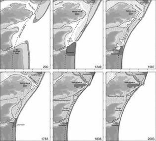
Figure 1: Coastal evolution at Dunwich Pye & Blott (2006)
Records of coastal erosion at Dunwich date back to before the Norman conquest (Comfort 1994). Figure 1, from Pye & Blott (2006) shows the most likely evolution of the coastline. Erosion north of Southwold fed the development of a southerly growing spit of sand and shingle. Over time this extended to enclose the harbour and estuary made by the river Blyth and Dunwich river. The southern mouth of the Blyth/Dunwich rivers was closed in the storms of 1328. Estuarine mud would have deposited rapidly within the enclosed basin, infilling the harbour area and constructing the marshes we see today.
To the south of the harbour the coastline changes as the land rises up to Dunwich heath. Here erodible cliffs of sand and gravel (Figure 2) are exposed during storms to wave action and undercutting, leading to collapse. The severity of wave erosion is strongly linked to the development of the shingle beach between mean high water and the cliffs (Lee 2008). In periods when this is eroded the cliffs are unprotected. Nourishment of this beach results from southerly drift from the shingle bank to the north.

Figure 2: Dunwich cliffs and beach looking north towards Southwold. Recent attempts at erosion protection can be seen on the beach.

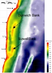
Figure 3: Offshore batymetry Pye and Blott (2006)
Off shore, the wave climate and sediment dynamics are influenced by the growth of the Sizewell and Dunwich banks. These are mobile and grow and decay. Silts and clays from the Blyth eastuary drift south and are caught in a northerly recirculation between the bank and the coast leading to very poor underwater visibility and accumulation over the site of the town.
