History

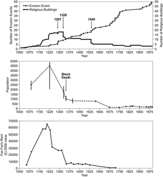
Figure 1: The rise and fall of Dunwich as measured by: (Top) the number of ecclesiastical buildings, (Middle) The population and, (Bottom) the economic value of the town as paid to the crown in taxes. The dates of significant events are highlighted. The period 1250-1450 was perhaps the most devastating in its history.

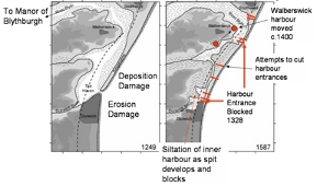
Figure 2: The decline of Dunwich was also linked to the economic viability of the town as a harbour. As the spit grew, Dunwich harbour silted and finally blocked. The Blythe and Dunwich rivers forced a new exit across the spit to the north, becoming permanent in the 16th century. Over time different attempts were made to cut new exits to the Dunwich harbour, and raids and murder were made on the Southwold and Walberswick seamen.
Most scholars agree that Dunwich was most probably the site of a Roman coastal fort, and was certainly a Saxon settlement (Comfort 1994; Bacon 1979). Divers from Suffolk Underwater Studies have tried to locate artefacts from the seabed to verify this theory, but so far without success (Bacon & Bacon 1975). The size of the original city is unknown, but was sufficiently important to have once been the seat of the first Bishop of East Anglia, and to have received Royal Charters for a Market and a mint (Bacon & Bacon 1979, Chant, 1986). In 1086 Dunwich was one of the ten largest towns or cities in England (Comfort, 1994). The wealth of Dunwich was based on sea trade and fishing. Indeed, the initial demise of the city is as much related to the continual battles to preserve the open harbour as to the physical losses arising from coastal erosion (Figure 2). In the 13th century, the city of Dunwich contained up to 18 ecclesiastical buildings (of which two remain Greyfriars monastery and St James - chapel to the Leper Hospital), a mint, a large guildhall and several large important houses (Comfort, 1994, Bacon & Bacon, 1979). The population has been estimated at over 5000 at its height, with at least 800 taxable houses, and an area of c.800 acres (Comfort, 1994).
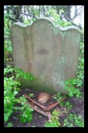
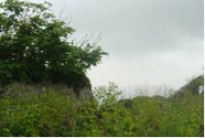
Loss of land at Dunwich is recorded as early as the Domesday book when over half the taxable farmland was lost to the sea between 1066 and 1086. Major losses were subsequently reported in the storms of 1328 and 1347, the latter resulting in the destruction of significant property (c.400 houses) in the low lying portions of the city. The decline of the city continued with losses in 1560 and 1570 such that by 1602 the town was reduced to a quarter of its original size (Comfort 1994; Bacon 1979). Further storms in 1740 flattened large areas of the remaining city, so that only All Saints church remained. The loss of All Saints has been well chronicled since it occurred during the early 20th century, finally disappearing over the cliff edge in 1919 (Figure 1). As of 2007, a final fragment and a single tombstone of All Saints Churchyard remains, and the south east corner of Greyfriars Monastery wall has started to collapse down the cliff.


Figure 3: The demise of All Saints church Dunwich. The decay and collapse of this the last of the town churches, epitomizes the decay of Dunwich in the late 18th to early 20th centuries. The ruins
attracted the attention of artists (including Turner), writers and poets. The ruins of All Saints now lie covered by the inner sand bank with some exposed in the gully that lies between the beach and the bank.
 Figure 4: Last remaining tombstone in All Saints Churchyard; to Jacob Forster, died 1796 aged 35. Human bones eroded from the church yard and recovered from the beach had been placed beside the tombstone. The juxtaposition of life and death is no where more apparent than at these sites.
 Figure 5: outheast section of Greyfriars monastery perimeter wall collapsing over the cliff. (Feb 2007). The beginning of the end for the last great monasatic building in Dunwich.
