Over the centuries, many different types of map have been made of the coastline and city of Dunwich. These can provide important information on the area of the city, the probable boundary of the city, and the locations of important structures that were likely to have survived on the seafloor. This information is crucial for designing the survey of the site. The first stage in the project was to collect together all the old maps of Dunwich.

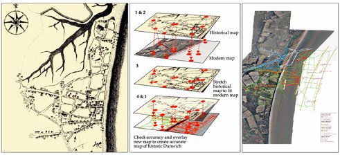
Figure 1: The process of geo-rectifying historic maps to bring them in to modern coordinate systems. Stage 1 - scan and digitize maps. Stage 2, select features common to modern and historical maps, stage 3, rubber sheet map to fit modern coordinates. 4 measure accuracy. 5 overlay maps to create accurate map of historical Dunwich.
The next stage (Figure 1) was to convert all the historical accurate maps in to a standard set of coordinates. For these we used a map projection called WGS84. Each map was scanned and the digital image was used to identify a range of points that were common to both the historical map and the modern maps, for which the coordinates of the features were known.
Using a computer package called a Geographic Information System (GIS) we selected the chosen points on the historical map and gave them the coordinates of the modern maps. We then used the GIS to stretch the digital version of the historic map to fit the modern coordinate system. This process is called ‘rubber sheeting’. A note was made of the accuracy of the new points since some parts of the ‘rubber sheet map’ are stretched more than others and can result in inaccuracies. If we were to use the maps to identify features on the seabed we needed the accuracy to be as good as possible.
Finally, when all the maps were in the same coordinate system (WGS84), we could overlay them one on top of the other to build the first digitally accurate maps of the city of Dunwich (Figure 1).
