Geophysical Techniques
The geophysical survey was conducted by EMU Ltd between the 5th and 7th June 2008. The survey used a suite of integrated computerised electronic systems, mounted on the shallow draught vessel the Emu Surveyor. These systems included the following:
- Position of vessel using satellite based Global Positioning (GPS). This told us where we were relative to the same coordinate system we had used for the mapping. This enables the location of seabed information collected by on board sensors to be determined with a high degree of accuracy, typically +/- 2 or 3 m.
- Pitch, role and yaw of the vessel using an internal electronic gyroscope (MRU). This helped us compensate for the movement of the vessel on the sea.
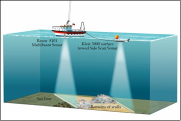
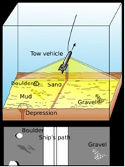
- Klein 3000 dual frequency (100 and 500KHz) sidescan sonar towfish & transceiver (Figure 1a). Side scan sonar is a specialized sonar (SOund NAvigation and Ranging) system for searching and detecting objects on the seafloor. A side scan transmits sound energy and analyzes the return signal (echo) that has bounced off the seafloor or other objects. In a side scan, the transmitted energy is formed into the shape of a fan that sweeps the seafloor from directly under the towfish to either side for up to a distance of 75 meters (Figure 1b). The strength of the return echo is continuously recorded creating a "picture" of the ocean bottom where objects that protrude from the bottom create a dark image (strong return) and shadows from these objects are light areas (little or no return). While the shape of the seafloor and objects on it can be seen, they do not provide any depth information.


Figure 1a: Survey set up using shallow draught vessel with Klein 3000 Sidescan Sonar towed on the
surface behind the EMU surveyor. 1b shows how the sidescan sonar esonifies the seabed.
Reson Seabat 8101 Multibeam Sonar. Multibeam sonar systems provide fan-shaped coverage of the seafloor similar to side scan sonars, but the output data is in the form of depths rather than images. Instead of continuously recording the strength of the return echo, the multibeam system measures and records the time for the acoustic signal to travel from the transmitter (transducer) to the seafloor (or object) and back to the receiver. The Multibeam sonar was attached to the EMU Surveyor, rather than being towed like the side scan. Therefore, the coverage area on the seafloor is dependent on the water depth.

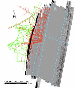
Figure 2: Survey area showing the light grey multibeam survey data overlying the black speckled sidescan sonar survey. The lines of blue dots are the Boomer tranects. The existing (green) and town as survyed in 1587 (red) are shown to provide scale. The survey covered most of the probable city site, with the exception of the harbour are to the north where the old Dunwich river is shown.
Applied Acoustics ‘Boomer’ catamaran with 100J energy seismic energy source (Figure 1). A surface-tow boomer system emits a high frequency (1-5kHz), low energy (100J) pulse allowing penetration beneath the seabed. This can be used to provide information on the shallow geology and to detect significant buried objects. The data is digitally recorded. Unlike the Multibeam and Sidescan Sonar, shallow seismic data from the Boomer is in the form of thin ‘slices’ located along the line of the vessel’s movement. This technology was applied at Dunwich to determine the depth of sediment over the site, and to test whether it was possible to detect any structures from the city. Four transects were surveyed (Figure 2).
All instrumentation were calibrated on site at the start of each day of survey. All data was post-processed to remove the effects of heave, pitch, roll and tide. The resulting data is of high quality and accuracy. Positions of seabed features are accurate to less than 3m for the multibeam, and to c.10m for the sidescan sonar.
